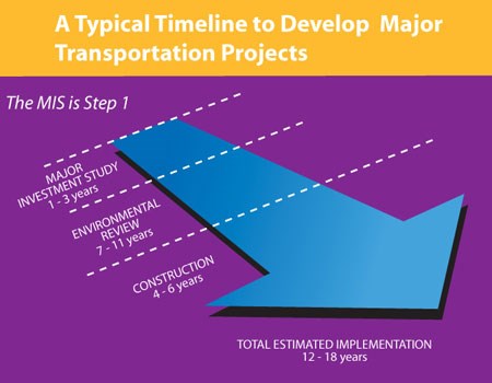
The Study
PHASE 1: Purpose and Needs/Initial Set of Transportation Improvement Alternatives Identified
Identify the Transportation Challenges and Develop Possible Broad Solutions
The study began in early 2006 to inform cities in the study area and to seek their input in the development of the study objectives. In early 2007, with the involvement of local governments, residents, communities and concerned groups, a draft Purpose and Need Statement and Initial Set of Alternatives was developed and approved by the OCTA Board of Directors in May 2007.
The Purpose and Need Statement provides the goals and objectives that the transportation solutions will try to address. The SOCMIS identifies eight key objectives that the study will address:
- Freeway Congestion
- Arterial (street) Roadway Congestion
- Weekend Congestion
- Lack of Transit choices (need more/better options)
- Rail Corridor Constraints (need to double track or re-route Metrolink rail lines)
- Economic Growth and Quality of Life
- Maximize Utilization of Existing Infrastructure (do better with what we have)
- System Gaps (complete unfinished road extensions, etc.)
Preliminary technical analysis and screening has been conducted on the 14 Initial Alternatives, and from them the Reduced Set of six Alternative Strategies were developed and approved by the OCTA Board of Directors in October 2007.
PHASE 2: Initial Transportation Strategies Reduced
The South Orange County Major Investment Study is developing transportation solutions to address the challenges facing south Orange County. The study team is currently reviewing stakeholder feedback on the proposed transportation elements that comprise the Reduced Set of Alternatives and combining it with the technical evaluation of the benefits, impacts and costs in order to develop a Locally Preferred Strategy that will be the basis for proposed transportation improvements in South Orange County for the next 20 years. The Locally Preferred Strategy can be one of the six alternatives or more likely will be a mix and match of the improvement concepts contained in the six alternatives. The following provides an overview of the transportation elements under consideration.
Transportation Problems, Needs, and Opportunities
Future Year Transportation Baseline Improvements
The study assumes what the transportation system will look like in 2030, if we do nothing beyond what is currently committed, this is known as the 2030 Baseline. Proposed improvements will be compared to the 2030 Baseline to determine what is needed on top of, or in addition to, the 2030 Baseline. The 2030 Baseline includes: completion of the Foothill South Toll Road, construction of committed arterial roadways (La Pata Rd., Alton Pkwy., Tustin Ranch Rd. and Cow Camp Rd. among others), 30-minute Metrolink service, etc.
Even with the anticipated completion of improvements already planned, additional capacity on south Orange County freeways and arterials is needed. In November 2006, this need was recognized by Orange County voters through the reauthorization of Measure M, the 1/2 cent sales tax for transportation improvements that proposed widening I-5 and I-405 and making improvements to interchanges and arterials.
Key Transportation Features:
- Complete the Foothill South Toll Road.
- Widen existing Toll Roads by one lane in each direction.
- Increase Metrolink Service to provide 30-minute frequency.
- Construct Committed Arterial Roadways including: La Pata Rd., Alton Pkwy., Tustin Ranch Rd., and Cow Camp Rd., among others.
Future Year Transportation Baseline Improvements
Future Year Transportation Baseline / Transportation System Management Improvements
Improve Transportation System Operations
Improves the roadway systems performance by investing in lower-cost operational improvements and enhances the efficient use of transportation resources.
Key Transportation Features:
- Transit Operations Improve transit service and accessibility.
- Alternative Modes/Intermodal Facilities Improve the attractiveness of alternative modes of travel.
- Transportation Demand Management (TDM) Reduce demand of auto trips.
- Freeway System Operations Operational improvements on I-5 and I-405.
- Arterial Roadway System Operations Improvements on major arterials.
- Advanced Traffic Management Systems (ATMS) Monitors and controls both freeway and arterial traffic systems.
- Advanced Traveler Information Systems Provides reliable, accurate and timely information on current traffic conditions to travelers.
Improve Transportation System Operations #1
Improve Transportation System Operations #2
Arterial System Improvements
Completion of the Master Plan of Arterial Highways (MPAH)
Objective: Close major gaps and relieve congestion on the regional arterial system throughout the study area. Provide roadway access and connectivity and facilitate traffic flow to south Orange County freeways and roads.
Proposed Transportation Features:
- Construct new arterial roadways.
- Widen existing arterial roadways that are currently below their MPAH classification.
- Provide new interchanges in selected locations to connect new arterials to the freeways and/or toll roads.
Completion of the Master Plan of Arterial Highways (MPAH)
Added East-West Arterial Capacity
Objective: Supplement the Master Plan of Arterial Highway (MPAH) improvements by providing east-west roadway capacity needed to keep pace with growing travel demand, addressing rapidly developing areas of southeast Orange County.
Proposed Transportation Features:
- Construct a new four-lane arterial road between I-5 and Antonio Parkway. Provide direct ramp connections to SR-73 and I-5.Widen Oso Parkway by one lane in each direction. Total width of Oso Parkway becomes eight lanes between I-5 and Antonio Parkway. Widen Ortega Highway further by one lane in each direction. Total width of Ortega Highway becomes six lanes between I-5 and Antonio Parkway. Includes MPAH improvements.
Added East-West Arterial Capacity
Focus Area - Added East-West Arterial Capacity
Freeway / Toll Road System Improvements
Widen I-5 and I-405 by One Lane in Each Direction in Some Sections
Objective: Add more lanes to the freeway system in locations that currently experience the most severe levels of freeway congestion. Correct interchange (on- and off-ramp) deficiencies in selected locations.
Proposed Transportation Features:
- Add general purpose lanes in some sections of I-5 and I-405.
- Add a northbound truck climbing lane to I-5 in the vicinity of Avenida Pico.
- Extend the existing High Occupancy Vehicle (HOV) lanes on I-5.
- Add direct HOV ramps in key locations.
- Provide interchange improvements in key locations.
- Saddleback Connector: Extend the freeway ramp system on I-5 between Avery and Crown Valley Parkways and add new freeway ramps to provide direct access to Saddleback College.
Widen I-5 and I-405 by One Lane in Each Direction in Some Sections
Widen I-5 and I-405 in All Sections Emphasizing General Purpose Lanes
Objective: Add mores lanes to the full length of the freeway system to relieve existing and future freeway congestion. Address interchange deficiencies throughout the study area.
Proposed Transportation Features:
- Add general purpose lanes to I-5 and I-405 needed to accommodate all types of traffic.
- Complete the High Occupancy Vehicle (HOV) system in south Orange County by extending the I-5 HOV lanes to the San Diego County line.
- Add direct HOV ramps in key locations.
- Provide interchange improvements in most locations.
- Includes Saddleback Connector and Truck Climbing Lane.
Widen I-5 and I-405 in All Sections Emphasizing General Purpose Lanes
Widen I-5 and I-405 in All Sections Emphasizing High Occupancy Toll (HOT) Lanes
Objective: Add more lanes to the freeway system in order to relieve existing and future freeway congestion. Allow single-occupant vehicles to buy their way in to the new lanes through the use of a toll. Address interchange deficiencies throughout the study area.
Proposed Transportation Features:
- Add additional lanes and convert the existing HOV lanes to provide a system of two HOT lanes in each direction on I-5 and I-405 (similar to the SR-91 Express Lanes).
- Provide ingress and egress to the HOT lanes at selected locations.
- Allow high occupancy vehicles to travel for free or at a lesser price.
- In addition, add general purpose lanes to some sections of I-5 and I-405.
- Provide interchange improvements in most locations.
- Include a northbound Truck Climbing Lane in the vicinity of Avenida Pico.
Widen I-5 and I-405 in All Sections Emphasizing High Occupancy Toll (HOT) Lanes
Widen Toll Roads by One Lane in Each Direction in Some Sections
Objective: Encourage greater use of the existing toll road system by widening the toll roads in the study area and by reducing the price of the tolls for users. Includes only key freeway improvements.
Proposed Transportation Features:
- Widen SR-73, SR-241, SR-133 by one lane in each direction.
- Reduce price for toll road users by employing a shadow toll.
- Widen some sections of I-5 and I-405.
- Includes: Saddleback Connector, Truck Climbing Lane, Direct HOV Ramps, and Selected Interchange Improvements.
Widen Toll Roads by One Lane in Each Direction in Some Sections
Transit System Improvements
Transit Investment in Bus and Rail
Objective: Enhance existing bus and rail service and introduce new types of transit services to address a variety of travel markets within the study area.
Proposed Transportation Features:
- Increase local and express bus services by improving frequency and geographic coverage.
- Substantial investment in community based shuttles.
- Introduce beach buses and special event shuttles.
- Increase the number of weekend trains between Orange and San Diego Counties.Add a new rail station in Lake Forest. Increase the amount and quality of transit services connecting to and from rail stations. Increase station parking capacity and station access.
Transit Investment in Bus and Rail
High Transit Investment in Bus and Rail
Objective: Improve transit travel times and trip reliability in order to attract discretionary riders. Address capacity constraints on the Los Angeles San Diego (LOSSAN) Rail Corridor within the study area. Improve access to passenger rail stations.
Proposed Transportation Features:
- Provide Bus Rapid Transit Route from Tustin Station to downtown San Juan Capistrano, serving transit centers and major activity centers along the route.
- Double-track LOSSAN Rail Corridor via tunnel, addressing areas that are currently single-track.
- Increase passenger rail service by adding more round-trip trains.
- Provide direct ramps from Jamboree Road to Tustin Station and from I-5 to Laguna Niguel Station.
- Add high-capacity rubber tire trolley service to high activity rail stations.
- Includes new rail station in Lake Forest.
The SOCMIS has moved through an extensive evaluation process that began by identifying the transportation challenges facing south Orange County over the next 30 years. Once the challenges were identified, a series of goals (also known as Purpose and Needs) were created for use as the criteria that potential improvements would address.
Next, an extensive list of potential transportation improvements was developed to address the transportation challenges. This list was composed of the 14 Initial Alternatives described in Phase 1. Technical analysis and public feedback helped to eliminate improvements that did not meet the study’s Purpose and Need, or were determined to be unfeasible due to cost, technical issues, impacts and/or public support. As a result, the Reduced Set of six Alternatives was formed.
OCTA then performed a more detailed analysis of the Reduced Set of Alternatives, and by mixing and matching various elements of each alternative, created the draft Locally Preferred Strategy (LPS). The LPS seeks to maximize mobility benefits, while minimizing impacts and costs to the extent possible.
The draft LPS is a package of transportation improvements that address the many modes of transportation that we rely on to get where we want to go. The improvements proposed enhance local transportation by using a regional strategy that encompass the freeway, toll road, street and transit systems.
The identification of an LPS is the first step to improving mobility for south Orange County. Following the approval of the LPS by the OCTA Board of Directors, staff will begin to identify timelines and strategies to move the individual elements forward to their next phase of study which includes additional technical and environmental work as well as community input.
Summary of the Draft Locally Preferred Strategy
The transportation improvements proposed in the draft Locally Preferred Strategy have been grouped together based upon the type and/or category of the improvement. Within the categories identified below, transportation improvements (such as, widening I-5 and I-405, and interchange and street improvements) that were approved by voters in November 2006 with the reauthorization of Measure M, the half-cent sales tax used to fund transportation projects in Orange County, are included.
For additional information, please click on any of the categories listed below.
- Future Year Transportation Baseline Improvements
- Projects that are committed through 2030 (baseline year) include those that have gone through studies resulting in environmental approvals and/or have an identified funding source
- Improve Transportation System Operations
- Improve street and freeway performance through operational improvements that maximize use of existing transportation infrastructure
-
Improve the Arterial (Street) System
-
Complete the Master Plan of Arterial Highways, a county wide plan that details the arterial (non-freeway) circulation system and provides a comprehensive planning tool that unifies local roadway plans to ensure regional balance and adequate capacity.
-
Conduct further study (if determined to be needed by the affected local governments) to consider how best to add East-West Arterial (street) Capacity.
-
-
Improve the Capacity of I-5 and I-405
-
Widen I-5 and I-405 in most sections
-
-
Study Opportunities to Maximize the Toll Roads for Overall Congestion Relief
-
Widen toll roads by one lane in some sections
-
Implement a reduced user toll through a shadow toll
-
Development Process
Future Year Transportation Baseline Improvements
Planning for transportation improvements takes place years in advance. Using information available today for the SOCMIS, the study team identified the transportation projects that are already planned and committed through the baseline year of 2030. This includes projects that have received environmental clearance, and/or have an identified funding source.
Key Transportation Features:
- Complete the 241 Toll Road
- Widen existing toll roads by one lane in each direction
- Increase Metrolink service to provide 30-minute frequency
- Construct committed arterial roadways, including:
- La Pata Road
- Alton Parkway Extension
- Tustin Ranch Road Extension
- Cow Camp Road
- And, more…
.jpg)
Improve Transportation System Operations
Invest in improvements that improve the operations and performance of the existing freeway and street systems. These operational strategies have lower cost and are designed to enhance capacity and efficiency, bringing near-term commuter benefits while more complex and large scale improvements are considered.Key Transportation Features:
- Improve transit service and accessibility
- Increase frequency and coverage of existing bus services up to 25% over projected Baseline 2030 levels
- Increase bus speeds using techniques such as transit signal priority and intersection ‘queue-jumper’ lanes (allows buses to by-pass waiting vehicles by receiving an early green in a special lane)
- Enhance the attractiveness of alternative modes of travel
- Improve and increase park-and-ride, and park-and-carpool facilities
- Enhance railroad quiet zones to reduce noise from more frequent train service
- Reduce demand for auto trips
- Encourage employers to use flexible work schedule to increase use of carpools, vanpools and transit
- Develop education programs on alternatives to driving alone
- Increase funding for vanpool and carpool programs
- Form Transportation Management Associations at high employment locations to encourage employer coordination of programs that reduce drive alone trips
- Improve operations on I-5 and I-405 to improve traffic flow
- Enhance technology monitoring traffic and improve response to traffic incidents
- Improve motorist information systems
- Improve freeway chokepoints
- Provide minor interchange improvements
- Improve operations on major arterials (streets) to reduce delay and improve traffic flow
- Implement safety and operational improvements
- Improve traffic signals
- Add additional turn lanes at intersections
- Implement safety and operational improvements
- Use “Smart Street” elements such as, signal coordination, bus turnouts and intersection improvements
- Implement Advanced Traffic Management Systems (ATMS) to monitor and control both freeway and arterial traffic systems based on existing conditions
- Monitor traffic conditions through automated Video Detection System
- Create data links between local cities and Caltrans Traffic Management Centers
- Implement additional traffic signal coordination and ‘smarter’ traffic signals
- Improve Advanced Traveler Information Systems (ATIS) to provide reliable, accurate and timely information on current traffic conditions to commuters
- Distribute continuous, real-time information on traffic conditions via changeable message signs (CMS), internet and in-vehicle systems
- Improve travelers’ ability to choose the quickest route, potentially reducing travel times
Improve the Arterial (Street) System
As South County continues to grow, congestion on local streets will continue to be significant as east-west connections remain limited. Closing major gaps in the arterial system will help to relieve congestion on South County streets. Additional studies are needed to determine how east-west roadway capacity can be increased to accommodate rapidly developing areas in southeast Orange County.Key Transportation Features:
- Complete the Master Plan of Arterial Highways (MPAH)
- Work in conjunction with local cities to complete the build-out of the MPAH system by constructing new roads, and widening existing streets that are below their MPAH classification (in terms of the number of lanes)
- Further study adding East-West Arterial (Street) Capacity
Further study of improvements to the arterial (street) system will only move forward at the discretion of the affected local governments.
- Consider widening Oso Parkway by one lane in each direction so that Oso Parkway becomes eight lanes between I-5 and Antonio Parkway
- Consider building a new four lane arterial roadway between I-5 and Antonio Parkway with direct ramp connections to SR-73 and I-5
- Consider further* widening Ortega Highway by one lane in each direction so that Ortega Highway becomes six lanes between I-5 and Antonio Parkway
*Environmental studies to widen Ortega Highway (SR-74) to two lanes in each direction between I-5 and Antonio Parkway are currently under way.
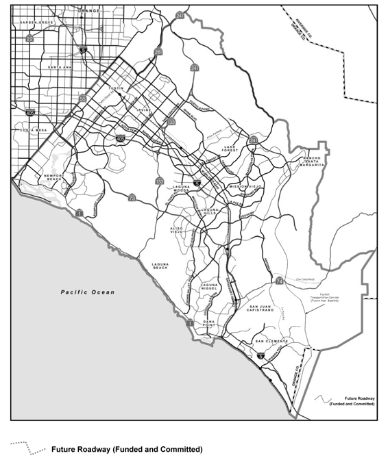
Click here to view the map of proposed improvements to the arterial system.
.jpg)
Click here to view the proposed SR-73/SR-241 connector concepts.
Widen I-5 and I-405 in Most Sections
Adding lanes to the freeway system in locations that experience the most severe levels of freeway congestion will help increase capacity, improve travel times and maximize improved mobility while minimizing impacts to adjacent communities.
Key Transportation Features (I-5):
- Add 1 General Purpose lane in each direction on I-5 in the following locations:
- Avenida Pico to Ortega Highway
- Avery Parkway to Alicia Parkway
- Vicinity of SR-133 to the SR-55 ramps
- Add 1 High Occupancy Vehicle (HOV) carpool lane in each direction on I-5 from the San Diego County Line to Pacific Coast Highway (PCH)
- Modify interchanges on I-5 at the following locations:
- Avenida Pico
- El Camino Real
- Pacific Coast Highway
- Stonehill Drive
- Jamboree Road
- La Novia/Camino Capistrano
- Ortega Highway (SR-74)
- Avery Parkway
- Oso Parkway
- La Paz Road
- El Toro Road
- Ortega Highway (SR-74)
- Conduct further study of new access to I-5 in the vicinity of Saddleback College
- Add truck climbing lane on north bound I-5 from Avenida Pico through Avenida Vaquero
Key Transportation Features (I-405):
-
Add 1 General Purpose lane in each direction on I-405 from the El Toro ‘Y’ to SR-133
- Add 2 General Purpose lanes in each direction on I-405 from SR-133 to (the vicinity of) Culver Drive
- Add 1 General Purpose lane in the north bound direction on I-405 from (the vicinity of) Culver Drive to (the vicinity of) MacArthur Boulevard for lane continuity/balance
- Provide interchange improvements on I-405 at the SR-133 (e.g., ramp connector to south bound I-405 to north bound SR-133)
Click here to view map of proposed improvements to freeway/toll road elements.
.jpg)
Maximize the Toll Roads for Overall Congestion Relief
Improvements to the toll roads will help achieve a better balance between the freeway and toll road systems. Use of the toll road system will be improved by creating increased capacity and reducing the user cost.
Key Transportation Features:
- Add 1 General Purpose lane in each direction, which will allow the roads to continue to be attractive to toll paying users on:
- SR-133
- SR-73
- SR-241
- Improve the SR-73/Laguna Canyon Road/El Toro Road interchange
- Add new interchanges at:
- Jeffrey Road and SR-241
- Crown Valley Parkway and SR -241
- “CC” Street and SR-241
- Reduce the toll to the user via a "shadow toll." A "shadow toll" is when the toll paid by users is supplemented to the toll road operator through a third party and not by toll road users.
*Note: Any improvements/concepts proposed for the toll roads including lane additions, and the development and further examination of toll pricing options, including assessment of travel demand, financial implications, etc. must be done in coordination with the Transportation Corridor Agencies (TCA).
Click here to view map of proposed improvements to the freeway/toll road elements.
Invest in Bus and Rail
Encourage travelers to use public transit as a viable means of getting to the places they want to go. Investment in bus and rail transit systems will increase transportation choices, improve connectivity and reliability to increase the number of people choosing to use transit.
Key Transportation Features (Bus):
- Increase fixed-route bus service by improving frequency and geographic coverage
- Increase express bus service (which focuses on connecting residential areas to high employment areas, covering greater distances with fewer stops than fixed-route service)
- Provide a substantial investment in community-based shuttles
- Introduce beach buses and special event buses
- Create a north-south Bus Rapid Transit (BRT) Corridor from the Tustin Metrolink Station to downtown San Juan Capistrano, serving transit centers and major activity centers along the route
- BRT is a type of fixed-route bus service that includes features to increase the speed of the bus, such as priority at traffic signals, less stops, and fare collection at bus stops
- Encourage cities to develop multi-modal centers with HOV, bus, BRT, specialty bus, carpool, vanpool, and parking facilities
Click here to view map of proposed bus transit improvements.
Key Transportation Features (Rail):
- Add a new Metrolink train station in Lake Forest
- Double-track (on a new alignment) the Los Angeles to San Diego (LOSSAN) Rail Corridor
- Study placing the rail tracks in a tunnel in some sections to avoid community impacts
- Expand weekend train service between Orange County and San Diego County
- Increase Metrolink station parking and station access
- Study the feasibility of creating a direct ramp from Jamboree Road to the Tustin Station (southbound direction only)
- Increase the amount and quality of transit services connecting to and from rail stations
- Utilize the plans developed through the Go Local Program to better connect communities to Metrolink stations
- Develop a fixed guideway transit line at select Metrolink stations with high volumes of commuters (for example, Irvine Station)
Click here to view map of proposed rail transit improvements.
.jpg)
.jpg)