Active Transportation Funding
Overview
The Active Transportation Program (ATP), administered by the California Transportation Commission and the California Department of Transportation, was created by SB 99 (Chapter 359, Statutes of 2013) and AB 101 (Chapter 354, Statutes of 2013) to encourage increased use of active modes of transportation, such as biking and walking.
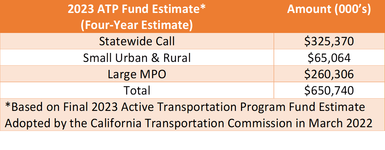
Fifty percent of funds will be awarded on a statewide basis. Forty percent of funds will be awarded to large metropolitan planning organization (MPO) with population greater than 200,000. Ten percent of funds will be awarded to small and rural regions with populations less than 200,000.
Section Manager, Discretionary Funding Programs
Active Transportation Coordinator
The purpose of the Active Transportation Program is to encourage increased use of active modes of transportation by achieving the following goals:
-
Increase the proportion of trips accomplished by biking and walking,
-
Increase safety and mobility for non-motorized users,
-
Advance the active transportation efforts of regional agencies to achieve greenhouse gas reduction goals,
-
Enhance public health
Ensure that disadvantaged communities fully share in the benefits of the program
-
Provide a broad spectrum of projects to benefit many types of active transportation users
Announcements
Submittals
As part of the 2023 ATP, applicant agencies within Orange County are required to provide copies of applications to OCTA and the Southern California Association of Governments (SCAG). Please email a file sharing link with a downloadable copy of your submittal to:
Denise Arriaga Ibarra
Senior Transportation Funding Analyst, Discretionary Funding Programs
darriaga@octa.net
If you are unable to provide a link, please contact Denise Arriaga for access to a file share site for uploading. The files will be shared with SCAG.
ATP Allocation and CTC Deadlines
Prior to advertising and awarding the contract, each project must receive an allocation from the California Transportation Commission (CTC). For federally funded projects, Authorization to Proceed for each phase of work is also required after the allocation has been granted.
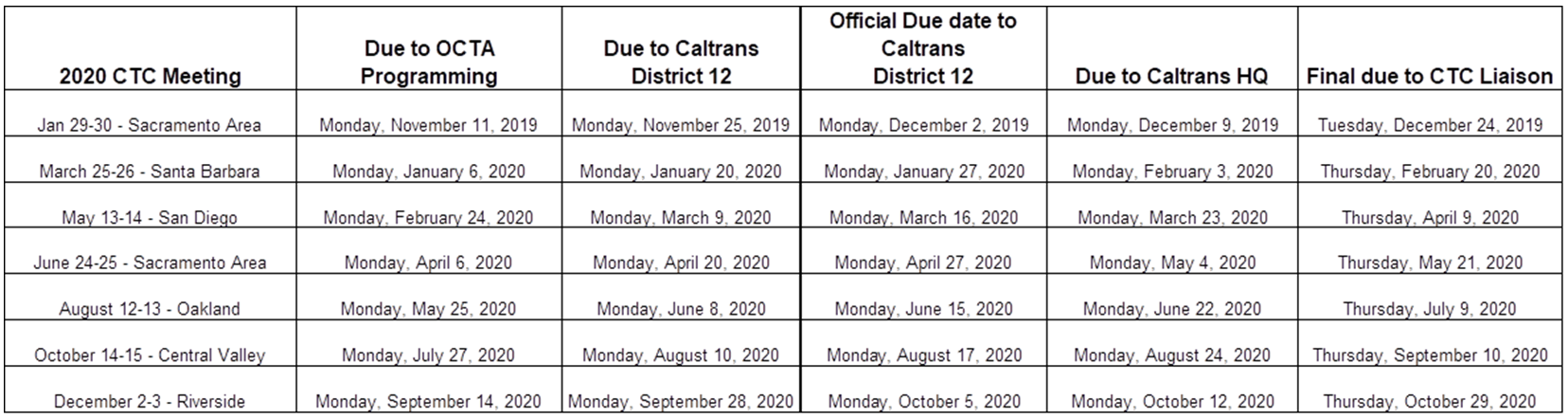
Regional (MPO) Call Project allocations require OCTA concurrence and review and are first processed through OCTA Programming, and then through Caltrans District 12, Caltrans HQ and the CTC Liaison. Statewide Call Projects do not need to be processed through OCTA and can be directly submitted to Caltrans District 12. Deadlines are available in the CTC Preparation Schedule.
CTC Preparation Schedule
Resource Links
Application Resources
The Regional Transportation Plan/Sustainable Communities Strategy (RTP/SCS) is a long-range visioning plan that balances future mobility and housing needs with economic, environmental and public health goals. The RTP/SCS embodies a collective vision for the region’s future and is developed with input from local governments, county transportation commissions (CTCs), tribal governments, non-profit organizations, businesses and local stakeholders within the counties of Imperial, Los Angeles, Orange, Riverside, San Bernardino and Ventura.
The RTP/SCS is an important planning document for the region, allowing project sponsors to qualify for federal funding. The plan takes into account operations and maintenance costs, to ensure reliability, longevity and cost effectiveness.
Every four years, the Orange County Transportation Authority (OCTA) develops the Long-Range Transportation Plan (LRTP), which OCTA uses to identify projects that can be funded over the next 20 to 25 years, and to evaluate their impact on future travel conditions. This also provides an opportunity to consider what planning initiatives are needed by OCTA to further improve Orange County’s transportation system. Once complete, the LRTP serves as the blueprint for future projects and as OCTA’s input into the Regional Transportation Plan for Southern California. This ensures that OCTA’s projects are eligible for state and federal funding and allows projects to move through the formal project development process.
OC Active Report - December 13, 2019
Final Report - June 28, 2013
The CBSP is a regional planning document that identifies existing and proposed bikeways in Orange County. Through the cooperation of the cities and the County, an inventory was taken of existing bikeways, and priorities for new bikeways were identified. Prioritization of the proposed bikeways, as identified in the plan, was based on several factors, including input from local jurisdictions and the public, as well as connectivity to transit and regional destinations.
In addition to analysis of existing and proposed bikeways, the document provides information on bicycle amenities, such as bike lockers, parking, signage and trail markings. It also includes a discussion of safety and education programs, innovative roadway markings, bikeway fundamentals and funding sources. The CBSP will be replaced by OC Active, covering both bicycle and pedestrian topics.
2009 OCTA Commuter Bikeways Strategic Plan
Other Resources
Note the following resources are available to help forecast future walking and bicycling trips related to infrastructure projects. See also the Caltrans Cost Benefit Analysis Tool.
The following are statewide databases to sort and map collisions.
County of Orange Health Care Agency (OCHA) has offered their services to assist agencies with data and grant application preparation. The following resources may be used in preparing the Public Health section of the application:
-
AskCHIS Neighborhood Edition (Free Registration and Log In required)
-
County of Orange Health Care Agency - Public Health Services
Jessica Hodgeson, Manager, Health Promotion Unit
jhodgeson@ochca.com
(714) 834-5728
-
Active Living Research – How to Increase Daily Bicycle Travel
-
Ralph Buehler, John Pucher – Cycling to work in 90 large American cities: new evidence on the role of bike paths and lanes
-
Reid Ewing, Robert Cervero – Journal of American Planning Association – Travel and the Built Environment
-
Gregory W. Health et al. – Journal of Physical Activity and Health – The Effectiveness of Urban Design and Land Use and Transport Policies and Practices to Increase Physical Activity: A Systematic Review
-
Gavin R McCormack and Alan Shiell – International Journal of Behavioral Nutrition and Physical Activity - In search of causality: a systematic review of the relationship between the built environment and physical activity among adults
-
Jenna R Panter et al. – International Journal of Behavioral Nutrition and Physical Activity - Environmental determinants of active travel in youth: A review and framework for future research
-
John Pulcher et al. – Preventative Medicine - Infrastructure, programs, and policies to increase bicycling: An international review
-
Brian E. Saelens, Susan L. Handy – Med Sci Sports – Built Environment Correlates of Walking: A Review
Less than 80% of the statewide median income (less than $51,026)
Links: data.census.gov/cedsci
arb.ca.gov
CalEnviroScreen 3.0
An area identified as among the most disadvantaged 25% in the state according to the CalEPA
Link: under SB 535 List of DACs: calepa.ca.gov
National School Lunch Program
At least 75% of public school students in the project area are eligible to receive free or reduced-price meals under the National School Lunch Program. The project must be located within two miles of the school(s).
Link: cde.ca.gov
CALIFORNIA CONSERVATION CORP - Orange County Contacts:
Katharyn Muniz
komuniz@occorps.org
(714) 956-6222 ext. 302
Josh Volp
jvolp@hireyouth.org
(714) 956-6222 ext. 221
For general ATP questions:
Julie Wolsey
Julie.wolsey@ccc.ca.gov
(530) 223-3045
Local contact in Pomona (includes LA):
Duane Wilson
Duane.wilson@ccc.ca.gov
(909) 594-4206