I-5 (County Line to Avenida Pico)
I-5 Freeway Improvement Project from the San Diego County Line to Avenida Pico
The I-5 Improvement Project from the County Line to the Avenida Pico Interchange proposes to increase person and vehicle throughput in south Orange County.
Project Overview
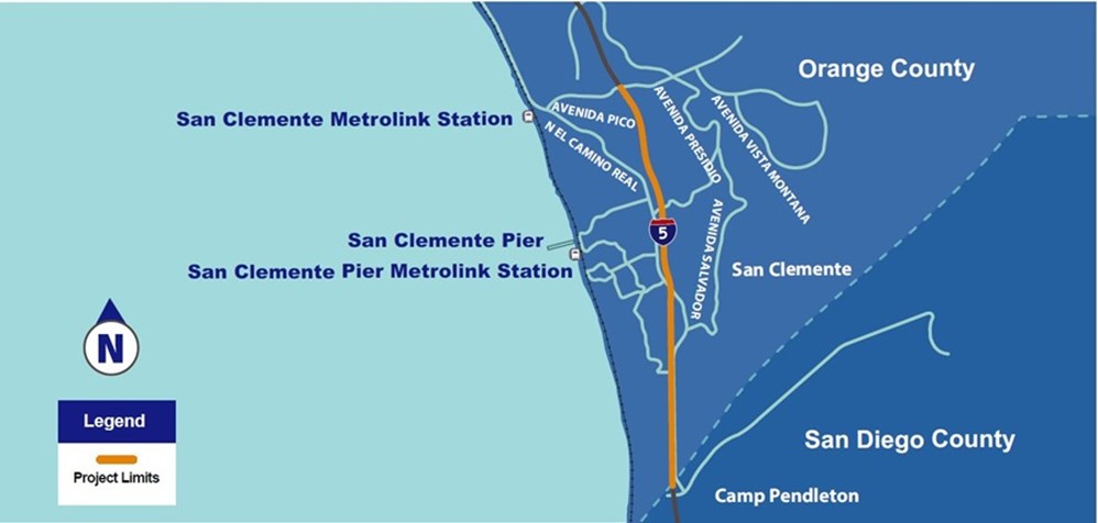
The Orange County Transportation Authority (OCTA), in cooperation with the California Department of Transportation (Caltrans) District 12 are proposing improvements to 4.8 miles of Interstate 5 (I-5) in the City of San Clemente from south of the San Diego County line to Avenida Pico (Project). The map below provides a high-level snapshot of the entire project area, with the proposed improvement area highlighted in yellow.This project is one of three being advanced as part of a 2020 agreement between the Orange County Transportation Authority (OCTA), the Transportation Corridor Agencies (TCA), and Caltrans to help address near-term South Orange County traffic relief. This agreement officially ended the TCA’s effort to extend the 241 Toll Road. To read more about the agreement, click here.
The Project is in the environmental review phase, during which the Project Report and Environmental Document will be developed. One No Build Alternative and one Build Alternative will be studied
Alternative No. 1 (No Build): The No Build Alternative proposes no improvements to I-5, maintaining the existing four general-purpose lanes throughout the Project limits in the northbound and southbound directions. The freeway facility would remain as is, with the exception of other proposed projects that are either under development or currently under construction
Alternative No. 2 (Build Alternative): Alternative 2 proposes to add an HOV lane on I-5 in the northbound and southbound directions within the project limits. The new HOV lane would connect to the existing HOV facility to the north of the project study area and extend south to the San Diego County/Orange County Line. The existing southbound inside general-purpose lane would be converted to an HOV lane between Avenida Pico and Avenida Presidio, the proposed southbound HOV lane would require outside widening to reestablish the fourth general purpose lane between Avenida Presidio and the San Diego County/Orange County Line, where the southbound HOV lane would become the inside general-purpose lane, and the outside general purpose lane would transition to an auxiliary lane and ending south of the southbound Cristianitos Road exit ramp at the County Line. In the northbound direction, I-5 is proposed to be widened to the outside to accommodate the additional HOV lane. The additional HOV lane will tie into the existing HOV lane at Avenida Pico. To accommodate the freeway widening, the widening or replacement of several bridges would be required. The Build Alternative would implement ramp improvements where feasible and auxiliary lanes throughout the corridor and would include Transportation Systems Management/Transportation Demand Management (TSM/TDM).
The I-5 freeway, a major freeway corridor, serves as a:
- Inter-regional and interstate travel and goods movement route.
- Connection between Orange County with San Diego County to the south and to Los Angeles County to the north.
- Main route to beaches and tourist attractions in the City of San Clemente, San Onofre State Beach, and United States Marine Corps Base Camp Pendleton.
To view the project presentation delivered to the City of San Clemente City Council, click here
Project Details
The preliminary engineering and environmental review process is a multi-year process that includes technical studies and opportunities for public participation and comment, including a public scoping meeting and public hearing.
Generally speaking, the environmental process is a 6-step process. The graphic below provides a high-level overview of the process, including a brief description of the purpose and work that takes place at each step. Currently, the environmental process is estimated to be completed in Early 2025.
However, please note that the project schedule is subject to change.
Project Milestones
|
milestones
|
TIMELINE |
|---|---|
| Project Initiation OCTA, Caltrans and the City of San Clemente partnered to initiate the development of the proposed project |
Spring 2021 |
| Notice and Public Scoping Meeting | Summer 2022 |
| Technical Studies & Draft Environmental Document Technical experts will conduct preliminary engineering and technical studies for the Draft Environmental Document (DED) |
Summer 2022 - Late 2024 |
| Public Hearing and Circulate Draft Environmental Document Technical studies will be compiled into the DED available for public review and comment during a 30-day circulation period. During circulation a public hearing will be held with informational exhibits on display and the project team available to respond to questions. The public will have the opportunity to provide written and verbal comments |
Early 2025 |
| Identify/recommend preferred alternative The project development team will identify/recommend a preferred build alternative based on the result of the technical studies and public comment. Caltrans is responsible for the final approval of the preferred build alternative and Final Environmental Document (FED). |
Early 2025 |
| Approve Build Alternative Final Environmental Document The FED will include identification of the preferred alternative and final approval by Caltrans. Response to comments received during the circulation period will be included in the FED. OCTA will give notice of the FED availability and provide the public opportunity to review. |
Early 2025 |